Agriculture
3 Steps for Measuring Irrigation Ditch Water
By Wyatt Hatch, PE
Am I getting enough water? This may be the most frequent question agricultural water users ask during irrigation season.
Irrigators depend on efficient systems to provide water when it’s needed, not to mention making sure their water rights are fulfilled.
Agricultural irrigation systems are typically supplied from surface water that is often times delivered through an open channel ditch. Using open channel flow measurement is an effective way to understand whether you’re getting enough water.
If you have the right equipment, open channel flow measurement is straightforward, effective, and needs little time and effort to perform. After a series of flow measurements have been collected at varying stages, a simple staff gauge reading can be used to determine the flow at any discharge stage and allow you to determine if you are getting enough water during irrigation season.
The following three steps will allow you to determine your irrigation ditch flow:
Step 1: Select Your Site
Select a site that best represents the overall channel. A good site will have most of the following characteristics:
- Straight and uniform section (approximately 300 feet upstream and downstream).
- Desirable measurement sections (i.e. rectangular, parabolic, trapezoidal).
- Clean section of the ditch that is free from debris (i.e. boulders, weeds, etc.).
- Consistent water velocity throughout section confined in one channel (greater than 0.5 ft/s).
- Low turbulence.
- Wadable.
- Location far enough removed from a stream confluence so backwater effects are not present.
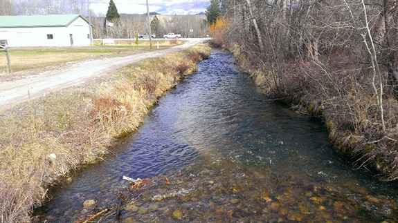
This section of open channel ditch is ideal to perform flow measurement calculations.
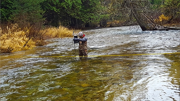
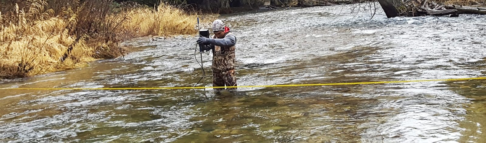
The author, Wyatt Hatch, takes measurements along the cross-section. The yellow string line is used to mark the cross-section and measure your location.
Step 2: Establish a Measurement System
The next step is to determine the most appropriate method for recording measurements.
Measurements are taken and recorded perpendicular to the flow by using a flow measurement instrument. The instrument will measure both velocity and depth (see photo below). There are a variety of instruments available to measure flow velocity and depth and an internet search will turn up many vendors for those interested in purchasing their own equipment.
Follow these steps:
- Once you have selected the site, measure the top width of the channel. Between 20 and 25 measurements across that width is typical, however, this number should be adjusted so each measurement contains no more than 5-10 percent of the total flow. Depending on channel width, measurements will be closer together to render an accurate result. For example, water is typically deeper and faster in the main flow of the stream (thalweg). Therefore, intervals will be closer together to make sure 5-10% flow for each section is consistent. Adjust measurement intervals as needed, keeping the flow percentage in mind.
- At each measurement location, record the depth of water using a flow measurement instrument like a wading rod or measuring tape. Measure the velocity.
- For the purposes of irrigation ditches, there are generally two methods: the “two-point” method and the “six-tenths-depth” method:
- Two-Point Method. This method records velocity measurements at roughly 20% and 80% of the depth below the water surface. The resulting values from each cross-section are averaged to represent the mean velocity of that partial section. This method should be used for depths of 2.5 feet or greater.
- Six-Tenths-Depth Method. This method records velocity measurement at 60% of the depth below the water surface. This value is considered the mean velocity of that partial section. This technique is best for flow depths between 0.3 feet and 2.5 feet.
Step 3: Calculate Flow
To better understand open channel flow measurement, it is helpful to have a basic understanding of the principle behind the process, otherwise known as the “continuity equation.” The premise behind this equation is simple: what you put in is what you get out.
For this application, flow in is equal to flow out:
V1A1 = V2A2 (Q1 = Q2)
Q=VA (Q = flow, V = velocity, and A = area)
At any given point within the channel, these equations indicate that flow into the ditch equals flow out of the ditch. To calculate the total flow, take measurements of the channel’s velocity and depth at multiple locations along the ditch, as discussed earlier. The result of all the measurements provides the flow within the ditch.
Your flow measurement instrument may calculate the overall flow for you. If not, record the width, height, and average velocity for each partial section. Enter this data into a spreadsheet to calculate the total flow of the ditch. If you like, we have a spreadsheet pre-populated with the calculation fields. Feel free to download it here. The sum of all partial section flows equals the total flow within the ditch.
Irrigation Ditch Flow: We’re Here to Help
Open channel ditch flow measurement is a simple process that can be useful for farmers, ranchers, and irrigation districts. Selecting a suitable site, establishing an appropriate measurement system, and using collected data to calculate the total flow all contribute to the accuracy of the flow measurement.
We recognize that not all agricultural producers and irrigation districts have time to measure flow or may not want to invest in flow measurement instruments. In order to ensure you have enough water, you may want to consult a professional who has the equipment and expertise to perform these flow measurements.
However, in the event you have the time and resources to invest in your own equipment, we can help get you started by meeting with you on-site to recommend a good location and help with the measurement process. We can also help you establish a stage-discharge relationship once enough data has been collected for quicker flow readings with a staff gauge.
References:
USGS Discharge Measurements at Gaging Stations, Chapter 8 of Book 3, Section A, 2010.
USGS Measurement and Computation of Streamflow: Volume 1. Measurement of Stage and Discharge. 1983.
Technical review of this article provided by Molly Davidson, PE
About The Author

As a land development engineer and project manager, Wyatt Hatch focuses on helping his clients achieve their objectives.
Learn more about Wyatt